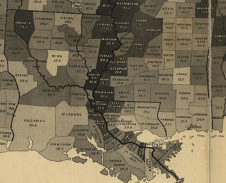
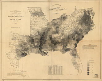
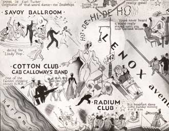
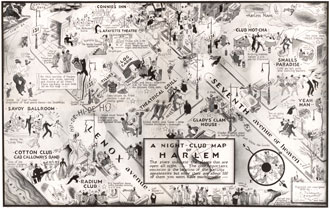
The opening image of the book may take some readers by surprise: it does not include America at all because it was drawn before Europeans “discovered” the western hemisphere. After the voyages of exploration in the 1490s, contemporary understandings of geography—and the world map—would forever be changed. Equally captivating is the final image of the book, a geo-visualization of data created for self-driving cars. Such a “map” is unlike any other in the book, for the data that guides autonomous vehicles is digital, never realized in a static form but always shifting. Yet as a tool of reconnaissance, movement, and discovery, it reminds us again that maps—above all else—shape decision making. To recognize this is to appreciate the power maps have to not just reflect the past, but to mediate it.That power of maps to drive historical change is nicely revealed by one of the first maps of the U.S. Census, drawn in 1860 to profile the distribution of slavery on the eve of the American Civil War.The map became a favorite not just of those on the Union home front, but also President Abraham Lincoln, who used it to construct a strategy to defeat the Confederacy. Though he initially promised to protect slavery where it existed, by 1862 Lincoln recognized that the rebellion would only be crushed when slavery itself—the Confederacy’s greatest resource—was destroyed. Emancipation was pressed first by slaves, then by Union generals, ultimately becoming a war strategy that culminated in the Thirteenth Amendment. The map riveted Lincoln because it showed him that the strength of the Confederacy varied by geography, a reality that lay hidden on other maps.One of the most provocative maps in the book comes a few chapters later, in 1932: a bird’s-eye view of the creative chaos in Jazz Age Harlem, drawn by the noted African-American artist Elmer Simms Campbell.Campbell arrived in New York after earning a degree in illustration at the Chicago Art Institute. While discrimination initially prevented him from working as an artist, he found solace in Harlem at the height of Prohibition. Guided by his best friend, Cab Calloway, Campbell immersed himself in the area’s energetic nightlife and profiled its most memorable characters. I use the map to explore not just that moment in time and place, but also the forces of migration, segregation, and culture that created Harlem and made it the capital of black culture in the early twentieth century. The map contains layers of commentary on race relations, gender dynamics, the selective enforcement of Prohibition, and of course contemporary jazz.My hope is that this book demonstrates that maps are essential artifacts of history. Judging from the enthusiastic reception the book has had to this point, I have every expectation that maps and graphic materials of all sorts will only become more central to the study of history. In my own research, maps have put into high relief people and places that otherwise remain invisible to the historical record. For instance, by studying hundreds of manuscript maps drawn by schoolgirls after the Revolution, I’ve come away with a deeper understanding of the way women were educated. There are many more examples like this, where maps don’t just complement our beliefs about the past but raise new questions about it.To put it briefly, when people hear me speak, or reach out to me about the book, the most common thing they say is this: I will never look at a map the same way again.